Discharge of precious groundwater impacted by sea level, ocean tides
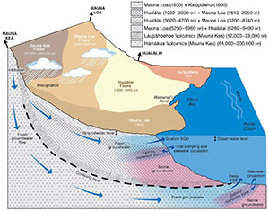
Groundwater is a vital resource for humans and ecosystems. Submarine groundwater discharge is a process by which water exits coastal aquifers and enters the ocean. This can be terrestrial freshwater or salty seawater that intruded into the porous aquifer at the ocean’s edge. While precipitation and sea level drive coastal groundwater levels, it is sea level, especially tides, that play gatekeeper on the amount of groundwater discharging to Hawaiʻi’s coastal zone, according to a study by University of Hawaiʻi at Mānoa researchers published in Nature Scientific Reports.
The addition of groundwater to the nearshore nourishes coastal food chains, supporting many traditional Native Hawaiian aquacultural practices, such as loko iʻa (fishponds). However, coastal aquifers and submarine groundwater discharge are increasingly affected by climate variations and sea-level rise.
“While rainfall drives the amount of freshwater in the aquifer, it is difficult to understand and predict the volume and timing of submarine groundwater discharge due to the complex nature of seasonal seawater intrusion, tidal pumping and wave set-up occurring on daily time scales,” said lead author Trista McKenzie, who was a postdoctoral researcher in the Department of Earth Sciences School of Ocean and Earth Science and Technology (SOEST) and is currently a postdoctoral researcher at the University of Gothenburg, Sweden. “In places like West Hawaiʻi where aquifer structures are complex and unknown, long-term observations are the only way to characterize this process.”

In 2016, Henrietta Dulai, professor of Earth sciences in SOEST, and colleagues, constructed an autonomous radon monitor, which can be used to calculate the magnitude of submarine groundwater discharge. The instrument was deployed in Kīholo Bay for several years with the support of Hui Aloha Kīholo and The Nature Conservancy, and collected data at an unprecedented length and resolution.
The instrument captured a revealing set of data, as it was deployed through significant weather events and ocean conditions including tropical cyclones, a tsunami, king tides, droughts, an El Niño period and sea-level anomalies. McKenzie and study co-authors, Dulai and Peter Fuleky, applied traditional and novel time-series analysis techniques to understand the patterns of submarine groundwater discharge—how it is affected by precipitation, tides and waves—and how it affects coastal salinity.
Data reveal drivers of groundwater discharge
The researchers found when rainfall is low, groundwater discharge and coastal salinity are modulated entirely by tides, with the largest discharge at low tide. When precipitation is above a threshold, it becomes a major driver pushing groundwater out of the aquifer and causing lower salinities at the coastline. This pattern is especially pronounced during El Niño periods.
Furthermore, during heavy rains, such as during tropical cyclones, coastal salinity decreases immediately due to freshwater flowing off the land surface. The team’s analysis also showed that high precipitation resulted in higher groundwater levels and a gradual increase in submarine groundwater discharge with a time lag of several weeks.
This research is an example of UH Mānoa’s goal of Excellence in Research: Advancing the Research and Creative Work Enterprise (PDF) and Building a Sustainable and Resilient Campus Environment: Within the Global Sustainability and Climate Resilience Movement (PDF), two of four goals identified in the 2015–25 Strategic Plan (PDF), updated in December 2020.
